
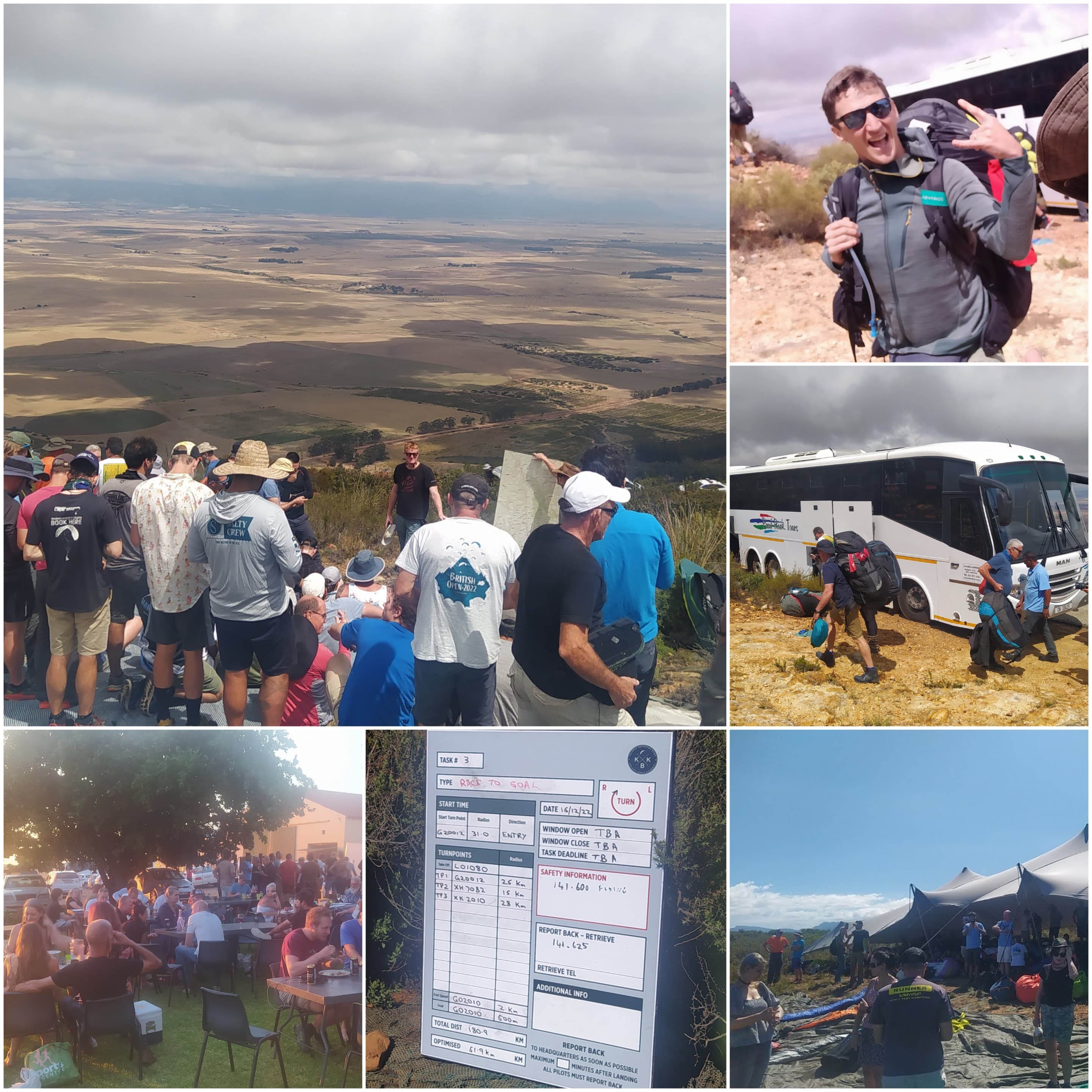
There's been quite a bit of discussion recently about El Niño and the coming Western Cape paragliding season.
I've heard concerns that Porterville could be "wild". More recently, there's been talk about predictions of a particularly dry and windy summer, followed by advice that pilots should therefore take extra care.
There may well be a hotter, drier or windier summer ahead. But I think we need to be careful about turning broad seasonal forecasts into paragliding safety warnings. A seasonal outlook is useful context. It is not a flying forecast. And the Western Cape weather micro met makes generalised forecasts less useful to the decision to fly.
El Niño is real. But what does it mean for paragliding in the Western Cape?
The current El Niño is significant. NOAA's September 2026 update says El Niño is strengthening, with a greater than 90% probability of a very strong event during the coming months. The Western Cape Government is also preparing for possible impacts, particularly higher temperatures, increased fire risk and pressure on water resources. Importantly, it notes that El Niño's most direct and severe effects in South Africa are normally experienced in the country's summer-rainfall regions.
None of that tells us what the wind will be doing at Dasklip (or Piketberg, Lions Head, Hermanus, Sir Lowry's Pass) at 13:30 on a particular December afternoon, and that's the distinction that matters.
Western Cape weather is complicated. Synoptic wind, intense inland heating, sea breezes, thermic circulation, mountainous terrain, and knock-on thermal effect from Langebaan into the Karoo, all interact. A forecast for a "windier summer" doesn't tell us where that wind will be strongest, at what altitude, at what time of day, or how it will interact with local thermic circulation. Does a stronger South Easter mean there'll be a delay in the sea breeze at Porterville giving us longer flying days, or perhaps more opportunities to fly from Piketberg to Elaandsbaai? Will the higher temps result stronger thermic activity up the Table Mountain north face and will this in turn positively affect the wind shadow at Signal Hill? There are too many variables to reduce a whole flying season to "El Niño means dangerous conditions" or "take extra care this season."
We have actually seen this before
The 2015/16 El Niño was also a major event. South Africa experienced major heat and drought effects. SAWS later reported that 2015 was the driest year nationally since records began in 1904, with exceptional heatwaves; Vredendal famously reached 48.4°C in October 2015. That same year the pilots at the Western Cape Open got to fly six consecutive tasks. I wasn't flying competitions yet — I only started competition flying in 2016.
Six tasks were flown on six consecutive days:
- 63 km
- 104 km
- 54 km
- 47 km
- 84 km
- 56 km
That doesn't mean El Niño caused good flying, and it certainly doesn't predict what will happen this December. It simply demonstrates that a strong El Niño and a very flyable Porterville competition can exist at the same time. Six consecutive tasks at PV including a hundy - I can tell you I've not been fortunate enough to experience this in my 10 years of comp flying in South Africa, I'm hoping this year changes that.
I've also spoken to several pilots who actually flew that event — back when it was still called the Western Cape Open, before it became the Porterville Paragliding Open. There's real excitement building for this coming season. We'd all love to have some 3000 m days: getting high, working the flats properly, and maybe finding some interesting new routes, both for our own recreational cross-country flying and for the competition itself.
What the 104 km day actually looked like
Curiosity got the better of me, so I dug up the IGC files from that 104 km task and ran them through Parametrics.app to see what the flying actually looked like that day, not just the resulting distance.
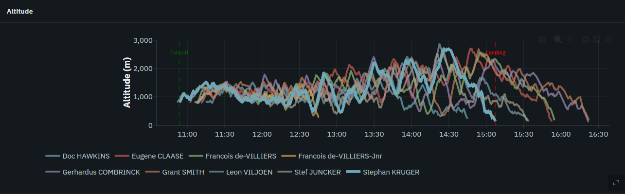
The altitude timeline across the field tells the story on its own: pilots grinding between roughly 1,000 m and 1,500 m for the first couple of hours, before the day properly comes into its own from early afternoon, with several pilots working thermals up past 2,500 m and the field topping out close to 2,800 m around 14:30.
I highlighted the clean climb-rate data out of two pilots' files in the screenshots here — Francois de Villiers and Gerhardus Combrinck. That's not because nobody else climbed well; it's because the tracklogs of the other pilots I analysed had data issues such as 5sec intervals, or missing pressure altitude - issues that have a material impact on calculations such as climb rate, rate of turn, etc. For those two, though, the numbers are a nice illustration of what a strong Porterville thermal day can offer:
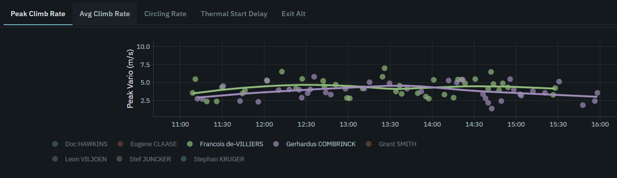
Peak climbs for both pilots sat in the 5–7 m/s range for most of the afternoon window.
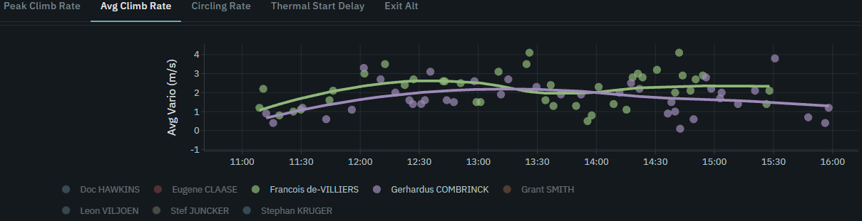
Average climb across the day held mostly in the 1.5–3 m/s band.
If you want to poke around the full report yourself, it's here on Parametrics. If you'd like to see a fun video with commentary on the selected pilots, check this out - oh and check out the strategic line choice of Stephan Kruger where he goes solo and absolutely owns the race.
The effect of high pressure on thermic activity
I like Kelly Farina's description of sticky and fizzy days (see his book Mastering Paragliding for more). Sticky (like honey) being the high pressure days, and fizzy (like a soda) being the low pressure days. Pressure by definition is the force of air mass over a given surface area. Air is made up of molecules which have mass. The higher the pressure, the higher the mass of air weighing down on the ground i.e weighing down on that parcel of air that wants to release from the ground and blossom into a beautiful thermal that can be ridden into sky. It takes a little more time and effort for these thermals to release, so when they do release they tend to have more energy than on a low pressure day and you encounter them less frequently, though the additional time on the ground also means they'll heat up a little more and therefore go higher. Therefore stronger less frequent climbs. Good thermal skills will result in you getting high, weak thermal skills will have you exiting early, and possibly encountering more rock 'n roll as you pass through the shear on the edge, and likely landing early because you didn't climb high enough to glide to the next thermal trigger. It's all about the circle-making skills - the higher the skill, the higher the climbs, the comfort in the sky, the longer the flight, the happier the pilot.
Post-frontal conditions and the lack thereof
We all know that post-frontal is the holy grail of thermal flying. El Niño is likely to give us a lot fewer post-frontal days. But that doesn't mean that we won't have great lapse rate days. What will make the airmass above ground level cold without a cold front, you ask? Enter those really strong south easter days, the days that the wind howls not just across Cape Town but across the Cederberg as well. This hated wind pulls in air that was over the Atlantic Ocean and pushes out the warmer stable air that's been sitting above ground level. It has a similar effect of "resetting the lapse rate," giving us the equivalent of a post-frontal reset. If the predictions are right, we should be having more of these.
Could a hotter, drier summer produce excellent XC flying?
Absolutely possible. More intense surface heating can potentially mean strong thermals, higher thermal tops and some excellent cross-country paragliding conditions.
It can also mean demanding conditions. Strong climbs can come with strong sink. Thermal edges can be turbulent. Dust devils may become more noticeable or frequent under suitable conditions. Afternoon winds can increase. That isn't necessarily bad flying — strong conditions and unsafe conditions are not the same thing. The important question is whether those conditions are appropriate for the pilot flying in them.
An experienced thermal and XC pilot may have an outstanding day in conditions that would be completely inappropriate for a newly licensed pilot whose experience consists mainly of coastal ridge soaring. That distinction exists every summer, across the Western Cape, from Hermanus to Porterville and everything inbetween.
Porterville isn't a ridge-soaring site
This is perhaps the more useful safety discussion, and it applies to all our mountains, not just Porterville.
One of the biggest mistakes pilots can make when moving from coastal flying into Western Cape thermal flying is treating the mountain like a ridge that needs to be soared. You might get away with this in winter, but in summer, you're moving your risks up, and if you choose to do this, it's best to have the skill to back it up. In thermic conditions, staying unnecessarily close to terrain reduces your options. The ground hurts. The earth doesn't budge. Take the earth on and you'll lose every time.
Instead, think of the ridge, peaks, cliffs and into-wind slopes as thermal triggers. Use the mountain to start your flight, but try not to spend the whole day near the terrain. The Porterville, no let me rather say the Western Cape flats work exceptionally well — you don't need to spend the day attached to mountains. This is also one of the reasons competition flying at Porterville has evolved.
We don't ridge race anymore
Modern Porterville competition task setting deliberately discourages ridge racing. We don't want to design tasks that reward pilots for racing low along terrain. Tasks are instead designed around thermal and XC flying, where pilots use climbs, make decisions and move through open air rather than relying on terrain proximity. That has been an important safety improvement and one we are very passionate about. At the 2025 comp we did have a Clanwilliam goal task, not a 100km task but still essentially a downwinder from Porterville to Clanwilliam - you'll note that on this occasion the turnpoint in the Porterville flats was moved further south than in 2015, this has the effect of pulling pilots off the ridge earlier for safety reasons. You'll find a fun video animation with commentary based on the pilots analysed here.
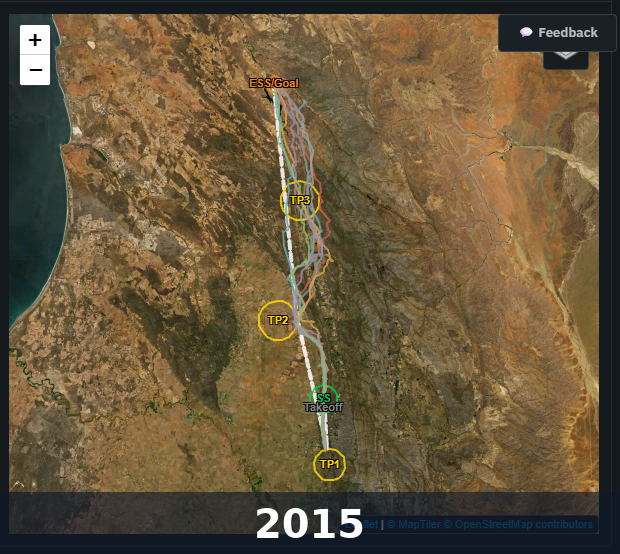
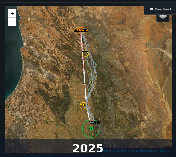
Put the two routes side by side and the shift in task design is easy to see. The 2025 line sits further out from the ridge for more of the route than the 2015 line did — exactly the kind of change that comes out of the task and safety committee process described above, not something anyone would necessarily notice from the results sheet alone.
The Porterville Open has another advantage: managed decision-making
For pilots worried specifically about the Porterville Paragliding Open, it's worth understanding what happens before a task is ever flown.
The task committee begins the day by examining multiple weather forecasts. We look at where conditions are suitable, where they may become unsuitable, what the wind is expected to do, the timing of the day and what routes make sense. Only then is a task designed.
After that, there is another gate. The safety committee operates independently from the task committee and reviews the proposed task from a safety perspective. It can consider the weather, route and the level of the pilots participating and question anything that presents unnecessary concern.
If a particular area is unsuitable, we don't send the field there. If the timing needs to change, we change it. If an appropriate task cannot be set, we won't set one.
Ironically, for a pilot who already has the appropriate thermal and XC skills, flying Porterville during a well-run competition can in some respects be a more managed environment than arriving alone with limited local knowledge and trying to work everything out yourself.
Do we need to take "extra care" this summer?
I'd phrase it differently: we need to take appropriate care every time we fly. There isn't a special category of El Niño caution.
Before flying, check the forecast. Look at the wind at different altitudes. Look at the Skew T's. Look for inversions or shear layers. Understand what is expected to happen during the day. Observe what is actually happening around the launch. Look for signs of dust devils before launching and also when setting up to land. Fly the day, not your desires.
If you don't yet have strong thermal skills, develop them progressively. And particularly in summer, don't make staying close to the ridge your survival strategy.
These aren't special precautions for 2026. They're the fundamentals of good paragliding.
Climate, weather, pilot
I think the simplest way to approach the coming season is to separate three things. Climate is what the season might generally tend towards. Weather is what the atmosphere is actually doing today. Pilot is whether today's conditions are appropriate for your skills.
El Niño belongs mostly in the first question. Your launch decision belongs in the third.
Maybe we're heading into a fantastic Porterville XC season with high bases, strong climbs and big distances. Maybe we're not. We'll know when we get there.
What we shouldn't do is turn a seasonal climate label into a paragliding hazard. Watch the weather, understand the conditions, develop the skills, and fly within your abilities.
And when the Cape gives us some good XC days this summer, let's go flying, I know I will and hopefully this summer will be one where I achieve a few more special routes that I've been after.
PS. Early bird fees for the comp end this month. It's still not too late to register.
PPS. Who knows, maybe this season will be the year when I add a parakite to my wing collection and join John Henderson for some late evening soaring sessions at St James.
Happy safe flying, Ria
Ready to learn to fly?
Air School Paragliding offers beginner paragliding courses in Cape Town. SACAA DTO certified. R12,500 — all gear included.
See the Beginner Course